To the Ends of the Earth
Without question, Antarctica is one of the harshest, most inhospitable places on Earth.
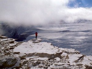
During the polar winter, temperatures can plummet to 100 degrees below zero over a near-empty landscape made up of broad icy plateaus and jagged ranges of bare rock. So alien is the continent that regions of Antarctica are studied as analogues for the terrain on Mars.
“It was just totally foreign to my sensibility,” recalls research fellow Claire Porter of her first visit to Antarctica two years ago. “There was no green anywhere. In Minnesota, even in the dead of winter, there are pine trees. It was very stark.”
It’s also deceptive. In the crystal clear air—there is virtually no humidity in Antarctica—and with little to provide a sense of scale, rock outcroppings or mountains glimpsed in the distance look much closer than they really are. “We’d look across the valley and see a rock and guess it would take a half hour for us to reach it,” Porter said. “Two hours later, the rock I initially thought was waist high would turn out to be several times my height and much farther away than we first imagined it to be.”
Porter is a remote sensing scientist with the Polar Geospatial Center (PGC) in the University’s College of Science and Engineering. In 2009 she joined the center as a graduate student and was hired as a full-time staff member after completing her degree.
"There are 1,200 people at McMurdo whose only reason for being there is to do science. It's a bad place for free time—but a wonderful place to concentrate and work." - Paul Morin
The Polar Geospatial Center began life in 2007 as the Antarctic Geospatial Information Center (AGIC) with a $400,000 per year award from the National Science Foundation. At the time, its founder and director, Paul Morin led a team of four that engaged in the groundbreaking work of taking hundreds of thousands of two-dimensional individual aerial and satellite images of Antarctica and turning them into high-resolution and 3D maps of the largely unmapped continent. In the spring of 2011, the organization received a five-year, $4 million grant from the NSF to expand its work to cover the Arctic as well as Antarctica, transforming the AGIC into the PGC.
Each Austral summer—roughly December through February—Morin, Porter, and other PGC members make the long trek to Antarctica to continue their work. Despite—or because of—the remote location and extremes of climate and topography, the continent is a hub of scientific research, drawing scientists and logistical support personnel to the United States’ McMurdo Station. As Morin describes it, “There are 1,200 people at McMurdo whose only reason for being there is to do science. It’s a bad place for free time—but a wonderful place to concentrate and work.”
For as much as 20 hours a day, researchers at the station, he said, “do science and talk science and it’s incredibly fertile.” It’s also, as he puts it, “very multidisciplinary—everyone has read everyone else’s papers.”
"It used to be that science drove imagery. Paul Morin and the Polar Geospatial Center have turned that around. Now they are creating imagery that's driving science." - David Marchant
McMurdo’s hothouse environment makes it an ample place of opportunity for undergraduate and graduate students working with PGC. Following his first trip to Antarctica two years ago, Spencer Niebuhr, who began working with the center as an undergraduate student, completed three internships in New Zealand and Australia with Antarctic researchers. He is one of less than a dozen undergraduate students at the station. “You can’t buy this experience,” Niebuhr said.
Now a research assistant with the PGC, Niebuhr plans to seek a master’s degree in remote sensing. “That’s not what I thought I was going to pursue,” he said. “But I just find it fascinating that we can do so much with satellite imagery.”
As of today, the PGC possesses what Morin calls “seamless coverage” of 90 percent of the Arctic region and 85 percent of the 14.5 million square miles in Antarctica. It provides an array of geospatial services and applications through the United States Antarctic Program (USAP) and now to researchers in the Arctic as well.
The center produces on-demand maps, GIS analysis (a geographic information system, or GIS, integrates hardware, software and data) including spatial, spectral and 3D analysis, and develops new software. It also serves as a repository of earlier maps of both the Arctic and Antarctica—a storehouse that now contains several hundred thousand images—directing researchers to the data they need and then accessing that material for them.
Each year the PGC sends staff to the Antarctic from October to January, where the center conducts its own on-site cartography. Among the fruits of this work are the PGC’s 3D models of all three of Antarctica’s permanent stations and new, much more detailed mapping of frozen lakes located in the McMurdo Dry Valley region.
In addition to supporting researchers’ scientific needs, the PGC supplies invaluable logistical support and locating safe places to land aircraft on frozen terrain often obscured from view by weather conditions. They also create detailed maps of supply routes for overland traverses, find good sites for establishing field camps, and analyze the landing sites of instrument-bearing balloons as they circumnavigate the polar regions, among other things.
The services provided by PGC have not only made it easier for researchers working at the poles to do their work, it has also advanced that work’s scope and accuracy. “What researchers want is not to do [mapping] themselves,” said Michelle LaRue, a PGC biologist. “They want someone to work with them. They want collaborators.”
LaRue, whose graduate degree is in zoology, cites a recent example of this collaborative approach. Researchers have been using PGC imagery to conduct a census of emperor penguins circling Antarctica. “After working on the data I saw that the same approach could be applied to seals,” she explains.
She followed up by contacting University of Minnesota wildlife ecologist, Robert Garrett, who is studying Weddell seals. “I asked if they were interested in working together,” she recalls. “They said, ‘Absolutely.’”
"You can't buy this experience." -Spencer Niebuhr
This spirit of enterprise, observes David Marchant, a professor of earth sciences at Boston University who works with the PGC in his search for clues to prehistoric climate change in the ice of Antarctica’s glaciers, places the center in a category of its own.
“It used to be that science drove imagery,” he says. “Paul Morin and the Polar Geospatial Center have turned that around. Now they are creating imagery that’s driving science.” Although the Polar Geospatial Center is only five years old, its origins go back much further.
More than 20 years ago Morin, then a University undergraduate and self-described “computer nerd,” was hired by University of Minnesota earth sciences faculty member David Yuen to do programming and visualization for work under way modeling the earth’s interior. Ultimately, that meant turning the visualizations into in-depth photos and animation.
Later, forming a company that provided 3D seismic visualization software for the oil industry, Morin returned to the University to manage a visualization project of the hydrologic history of Australia.
In January 2007, Morin was asked by a National Science Foundation program manager he’d met during the course of his work to attend an NSF workshop about the future of Antarctic mapping. There, Morin was asked if he could assemble a team that combined expertise in geology and remote sensing to work on mapping a section of the Transantarctic Mountains.
After two trips to the South Pole, Morin’s team created a 3D map illustrating the volcanic history of part of the McMurdo Dry Valleys. Not long after, he wrote up an NSF grant proposal to create a geospatial organization at the Univers-ity of Minnesota. In six months, the AGIC was born. A couple of years ago, the NSF polar office—which funds research in both the Arctic and Antarctic—asked Morin to expand to cover the North Pole, too. Today, the PGC has grown from its original roster of four to more than a dozen staff members, including eight graduate and undergraduate students.
In making the transition from focusing solely on the Antarctic to include the Arctic, the Polar Geospatial Center faces a change in emphasis rather than a radical alteration of its mission. “The big difference is that in our first year in the Antarctic, our work was 60 percent logistics, 40 percent science,” said LaRue. “In the Arctic, that ratio is flipped: 40 percent logistics, 60 percent science.”
Translation: one of the biggest differences between the Arctic and Antarctica is that the remote sensing the PGC will be doing for researchers at the Arctic will be less about finding out things like whether a particular spot is safe for landing a plane or helping a team of researchers find their way to the precise location where they were working the year before. Instead it will be more about precise measurements of a site using satellite and aerial maps with a resolution of a half meter or less.
But in the loose, ready-for-anything tradition of the unit, the staff at the PGC is looking forward to the new challenges. “I think our experience will serve us well,” said Brad Herried, the PGC’s carto-grapher and web designer. He points out that while the North and South Pole are on opposite ends of the earth—literally—they resemble each other in many ways, from climate to the kinds of research being conducted, to, in certain areas, terrain.
At the same time, the PGC doesn’t underplay the challenges that lie ahead. In Antarctica it has been able to work within a centralized structure of research and logistical support; in contrast, work in the Arctic is decentralized rather than concentrated in one or two bases, like McMurdo. In Antarctica, the PGC staffers can also meet virtually every researcher working the continent in a single Austral summer—not so in the Arctic. The fact that there is a multitude of research bases in the Arctic spread out all over the polar region will present some new issues in terms of outreach. But that’s not all.
“There are some different applications in the Arctic than in the Antarctic,” Herried points out. “There’s more biology, for one thing in the Arctic and there’s less ice, making the natural landscape more dynamic.”
“It will definitely increase our workload, but we know what we are getting into,” he said. “As an organization, it will lead to some challenges that we will need to solve, but we’re up to it.”