Mapping the world: Stergios Roumeliotis
When visitors arrive at Stergios Roumeliotis’ lab in the basement of Walter Library, they are apt to be greeted by graduate student Dimitrios Kottas holding a smartphone aloft.
“Follow me,” he says with no further explanation. The experience that ensues is, in some ways, a step into the future. As the smartphone screen portrays a real-time, full-color, 3D moving image of the halls and stairways and book-lined rooms of Walter, faint white lines on the screen trace the exact route taken by Kottas and his entourage.
What Kottas is demonstrating is just one of several projects Roumeliotis, a professor of computer science and engineering, is conducting. In this case, a handheld device helps visually impaired individuals find their way around unfamiliar terrain. It is work for which Roumeliotis was awarded an NSF grant some five years ago.
Since then, two of his former doctoral students, Joel Hesch and Esha Nerurkar, have gone on to help lead similar work as part of Google’s “Project Tango,” a smartphone application that will offer full-color, 3D indoor images showing consumers exactly where they are and what people and things are nearby. In addition to hiring CSE graduates, Google recently named the University of Minnesota one of its academic partners in the project.
Roumeliotis also recently received a $3.5 million NSF grant as part of the agency’s National Robotics Initiative. The money is funding research into “collaborative robotics,” which aims to create a new generation of interactive humanoid robots that will assist people with a variety of tasks, such as lifting and carrying heavy objects. Roumeliotis is conducting the research with fellow CSE faculty member Demoz Gebre-Egziabher, as well as with investigators from several other universities.
“We’re a robotics lab. That’s what we do,” said Roumeliotis, whose work in this area began some 10 years ago with research aimed at developing inertial and visual algorithms for use by NASA on its Mars rovers and spacecraft.
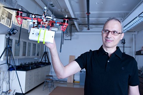
From there, he developed mapping devices to use on Earth where GPS cannot offer accurate data or where a finer order of mapping—millimeters rather than meters, as is the case with GPS—is needed. That, in turn, led to the research that began five years ago, now bearing fruit in “Project Tango.” Today, Roumeliotis is also involved in developing navigation algorithms for quadrotors—small, four-rotor aircraft equipped with inertial and visual sensors—that can fly into enclosed spaces and send back real-time video of what’s inside.
“Ground-based robots can go into a building looking for explosives or snipers but may get stuck on an obstacle or trigger an explosion,” he points out.
In similar situations, he explains, “You’ll be able to fly [a quadrotor] into a second story window and get the same information without the risk.”
“Whether it’s a spacecraft that lands on Mars or a cell phone here in Minnesota, the common theme is how to find your way around,” Roumeliotis said. “The hardware is the same, albeit of different quality, and the questions the software needs to answer are the same—where are we, how do we find our way, where do we want to go?”