Earth science researchers develop free mobile app for geoscience outreach
Track your flight with GPS and discover geological points of interest below
Ever look down at Earth from an airplane and say, “That's really cool, I wonder how that happened?” Well, now you can find out.
Funded by the National Science Foundation, researchers in the University of Minnesota’s Department of Earth Sciences have developed a new offline mobile app, called Flyover Country, for geoscience outreach and data discovery. The free app lets you track your flight with GPS and discover the world below with geological maps and points of interest.
The app analyzes a given flight path and caches relevant map data and points of interest, and displays data during the flight, without in-flight WiFi. By downloading only the data relevant to a particular flight path, cache sizes remain reasonable, allowing for a robust experience without an Internet connection.
Ideal for road trips and hiking, too
Flyover Country is not limited to the window seat of airplanes. It is also ideal for road trips, hiking, and other outdoor activities including field trips and geologic field work. Offline geologic maps and interactive points of interest reveal the locations of fossils and georeferenced Wikipedia articles visible from your road trip or hiking trail vista.
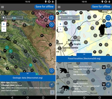
The app integrates interactive geologic maps from Macrostrat.org, fossil localities from Neotomadb.org and Paleobiodb.org, Wikipedia articles, offline base maps, and the user’s current GPS determined location, altitude, speed, and heading.
The app was developed by researchers in the Department of Earth Science’s National Lacustrine Core Facility (LacCore). They include Shane Loeffler, Amy Myrbo, Sijia Ai, along with senior software development consultant Reed McEwan (M.S. ’91).
In February 2016, the group announced a new, three-year grant from the National Science Foundation to make continued improvements to the app.