Caves and Karst
Almost everyone has heard of, read about, or visited caves. They provide a view into an underground world populated with bats and uncommon creatures such as blind, colorless insects and fish. Natural caverns, large enough to hold entire buildings, may contain beautiful and delicate structures fashioned by nature from water and rock.
Humans have been exploring, living in, and decorating caves for millennia. Today we can examine pictures on cave walls that illustrate the world in which humans lived thousands of years ago. For centuries, indigenous Americans and later European settlers in Minnesota have used natural and human-made caves along the Mississippi River bluffs in what is now the Twin Cities Metropolitan Area (Alexander, 1980). In the writings of Mark Twain, Tom Sawyer and others visited caves farther south along the Mississippi River. They are among other caves from literature including those described by Homer, J.R.R. Tolkein, and Agatha Christie. Some of our national parks, such as Mammoth Cave in Kentucky, and Carlsbad Caverns in New Mexico, were established to protect large caves and to provide public access to the unique and often fragile underground world. Caves excite interest both as places to explore and as places to study.
Caves are only one part of a group of landscape features known as karst. Karst landscapes are broad and regional in nature. In addition to caves, karst landscapes include, but are not limited to, underground streams, sinkholes, blind valleys, and springs.
Where does karst develop?
Karst landscapes can develop where limestone and dolostone are at or near the surface. Limestone is composed mostly of the mineral calcite (calcium carbonate); dolostone is composed mostly of the mineral dolomite (calcium magnesium carbonate). Over long periods of time, the carbonate minerals in these rocks are dissolved by rain and groundwater, creating karst.
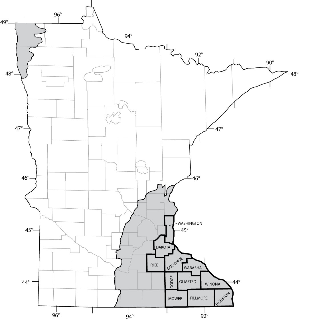
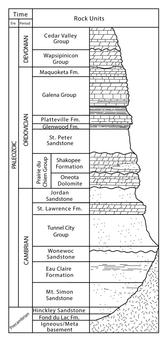
In Minnesota, limestone and dolostone underlie the southeastern corner of the state, which includes the Minneapolis–St. Paul Metropolitan Area. Similar rocks are also found deep beneath the surface in northwest Minnesota (Fig. 1). In southeast Minnesota, carbonate rocks from the Cedar Valley Group down through the bottom of the Prairie du Chien Group (Fig. 2) contain caves and other karst features. Because most of Minnesota is buried beneath a thick cover of glacial sediments, the karst landscape may not be apparent. In parts of southeastern Minnesota, erosion has removed most of this glacial cover and exposed the carbonate bedrock. Counties known for karst features include parts of Dakota, Rice, Dodge, and Mower, and most of Goodhue, Olmsted, Winona, Wabasha, Houston, and Fillmore (Fig. 1). Fillmore County has more caves, sinkholes, and disappearing streams than all other Minnesota counties combined.
Karst formation
Karst develops over millions of years and probably began to form soon after the carbonate rocks were deposited 500 to about 350 million years ago. Karst is an erosional process that changes the landscape by removing the carbonate rock at the surface and underground. The erosion may be physical, when pieces of rock are moved, or it may be chemical, when the rock is dissolved into its components and carried away in solution. Limestone and dolostone are subject to both physical and chemical erosion, but it is chemical erosion that produces most karst landforms. The result is similar to what happens when water flows onto a cube of sugar, but in rock, the features develop much slower. The carbonate minerals are removed by the water, leaving behind a small hole that over time becomes larger and may eventually form an enlarged joint, sinkhole, or part of an underground network of caves. The minerals dissolved in the water may later be redeposited as cave stalagmites and stalactites.
Karst features
Figure 3 shows characteristic karst features. On the surface, sinkholes form where soft sediment has collapsed, either gradually or catastrophically, into cavities in the limestone (Fig. 4). Sinkholes are the most abundant karst feature in southeastern Minnesota. They number in the tens of thousands and range in size from a few inches to tens of feet across and deep. It is difficult to predict where sinkholes will form, but many are aligned over joints in the bedrock. New sinkholes frequently form near existing sinkholes.
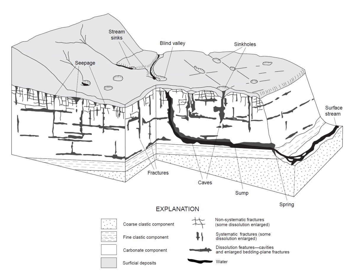
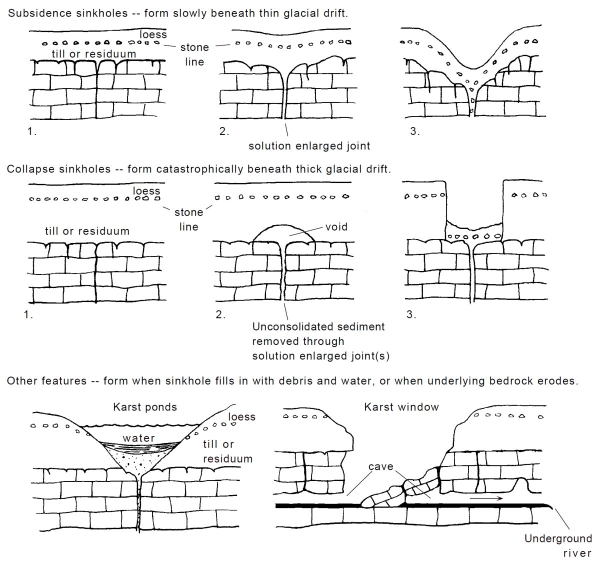
Surface-water flow in some minor streams may be diverted underground through fractures and openings in carbonate rock. This creates stream sinks and disappearing streams, where at certain times of the year, river flow is entirely underground, leaving dry valleys on the surface (Fig. 3). In places, streams may not completely cut a valley because all of the water goes underground, leaving a blind valley that ends in a wall with no surface outlet (Fig. 3). Groundwater returns to the surface at springs—in some places within the drainage basin where it first entered the ground, in other places, in a different surface valley and drainage (Fig. 3). Water emerging at springs in a karst landscape may have been underground for years or for only a few hours.
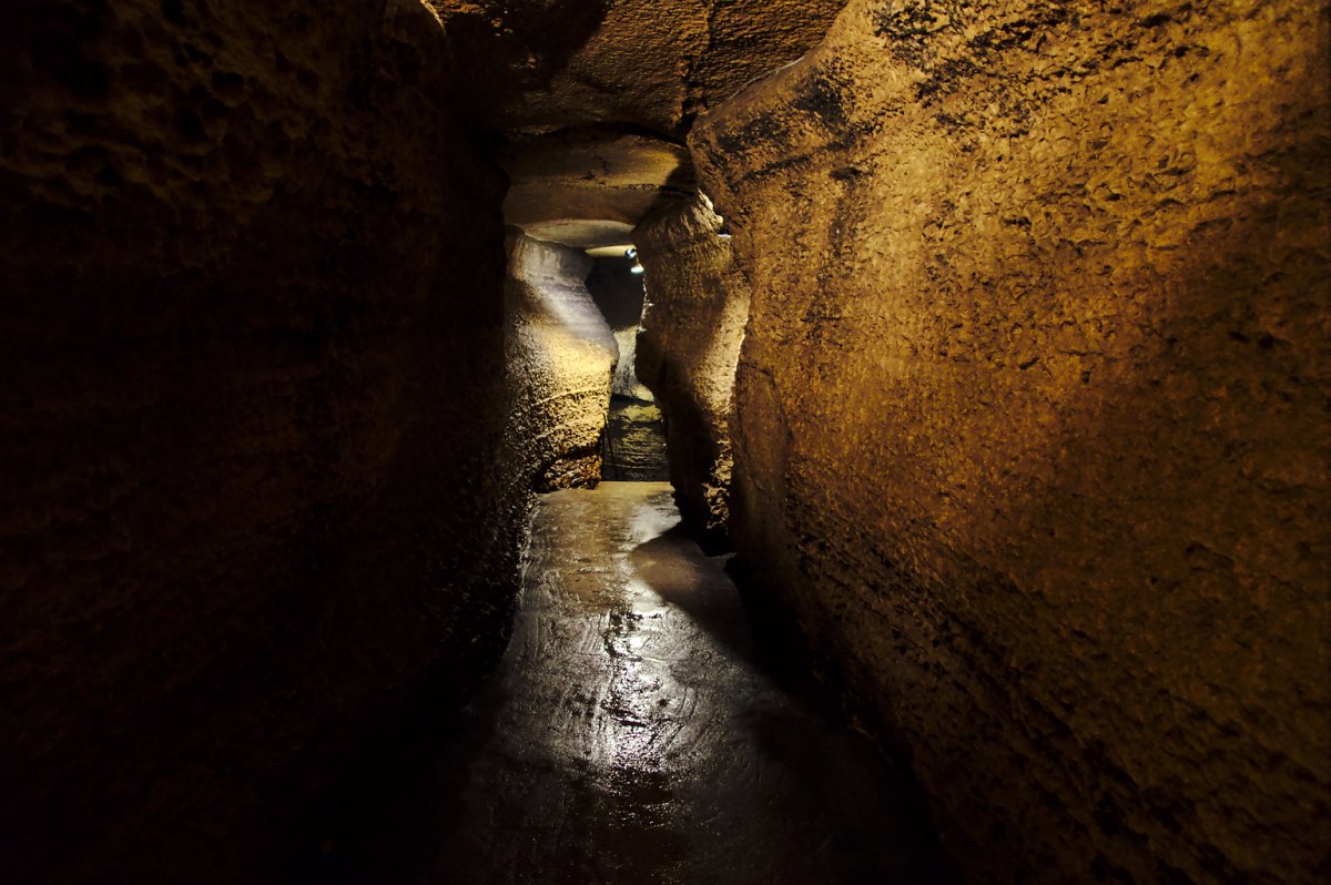
When cavities in the carbonate rock become large enough for human entry and exploration, they are known as caves (Fig. 3). Caves may consist of a single passage a few feet long or a large, multi-level maze with miles of passages and many surface openings. Active caves (those still being chemically eroded) contain streams, drips, pools, and sumps. Water level and "wetness" in a cave vary with the season and with climate. Passages that are dry during the winter may have many drip points or become flooded during spring snowmelt or after heavy rains. Caves that are inactive are dry most of the time.
Caves usually maintain a climate separate from that above ground. Caves "breathe"—exchanging air between the cave and the surface in response to changes in outside air temperature and barometric pressure. The temperature inside southeast Minnesota caves (away from an entrance) remains constant all year, not varying by more than a degree from 49° F, approximately the annual average surface temperature. Caves in different climate zones have temperatures that reflect the average surface temperature for that zone. The environment in caves that are wet or contain streams is also very damp, with relative humidity levels that are usually above 90 percent.
Protected from the more rapid erosion that occurs on the surface, caves contain indicators of past geologic events. The formation of a cave is, itself, a geologic event. Cave passages and walls, by their shape, structure, and location, can be used to tell if passages formed above or below a water table or when passages formed relative to one another. Mineral deposits and cave formations (also called speleothems), such as stalagmites and stalactites, are indications of air-filled passages and flowing or dripping water. A handy way to remember the names is that stalactites "hang tight to the ceiling," and stalagmites "might reach the ceiling from the floor." Both form where water drips from the ceiling. A third type of speleothem is flowstone and consists of horizontal mineral layers deposited by water moving across a surface. The presence of sediments implies transport and deposition by water, usually via streams and floods. Some cave sediment is actually a residue that did not dissolve with the limestone.
Speleothems and cave sediments may have been forming or been in place for thousands of years. The ages of speleothems can sometimes be determined in a laboratory. Using that information, geologists derive a better understanding of how karst development is related to other geologic events in the region. For instance, some passages in Mystery Cave, located in Fillmore County, are older than 160,000 years. These passages contain sediments originally deposited on the surface by glaciers that periodically covered the area during the past 2.5 million years. These sediments were later transported and deposited in the cave by streams. Along the public-tour routes in Mystery Cave, stream sediments are capped by flowstone that was deposited about 12,000 years ago, which is about the time that the last glaciers left Minnesota. In other caves in southeastern Minnesota, speleothems range in age from modern to greater than 350,000 years old.
Karst-related problems
Karst landforms are important. They provide pathways to transfer large amounts of water between the surface and aquifers, and in the case of sinkhole collapse, can rapidly alter the land surface in ways that range from a nuisance to an actual hazard.
Most karst problems in Minnesota are associated with pollution of groundwater and surface water, although the occasional collapsing sinkhole can be locally catastrophic. The easy and rapid movement of water between the surface and subsurface through sinkholes, joints, streams, and springs increases the potential for both groundwater and surface-water contamination. Agricultural and industrial chemicals, home and urban wastes, and sewage can easily move into the underground water system and be rapidly transported to other locations. This can contaminate a large area of the groundwater system within the limestone, but can also affect adjacent aquifers and streams where the water returns to the surface. Dye tracing has been used to establish connections between surface inputs and springs, and to identify subsurface drainage basins for several areas in southeast Minnesota.
Due to an increasing awareness that karst regions face unique pollution problems, groundwater protection in the karst of Minnesota has become a significant issue at the local and state level. The impact of karst pollution can be severe and costly, and solutions require coordinated efforts.
Cave exploration
Around the world there is evidence that caves have been explored since prehistoric time. Even now, new caves are forming, and many existing caves are unmapped. The adventure of underground exploration appeals to many people. A major lure of exploring caves is the chance to see sights only a few others have seen.
The best way to start exploring caves is by visiting commercial caves in Minnesota and surrounding states. Mystery Cave, in Forestville/Mystery Cave State Park in Preston, and Niagara Cave in Harmony, both in Fillmore County, are the only Minnesota caves open to the public for tours. Mystery is the largest cave in the upper Midwest, with over 12 miles of mapped passages. Niagara Cave contains an excellent example of an underground river, complete with waterfall.
Although several hundred caves are known in southeastern Minnesota, these caves are commonly on private property and are not suitable for casual outings. Exploring unimproved caves can be dangerous. For additional information, visitors should contact the Minnesota Speleological Survey or the National Speleological Society to learn what programs and activities are available.