Glacial Geology
- Quaternary Period
- What Are Glacial Deposits?
- Minnesota's Glacial History
- Minnesota's Glacial "Footprints"
Quaternary Period
in North America about 14,000 years ago (Lusardi,
1994, fig. 1).
The Quaternary Period began about 2 million years ago, and is divided into the Pleistocene Epoch (2 million to 10,000 years ago) and the Holocene Epoch (10,000 years ago to present).
Although 2 million years is a relatively short period of time geologically, sediments deposited during this time mask nearly all of Minnesota’s previous geologic history (as old as 3,600 million years!).
The Pleistocene Epoch, also called the Ice Age, is marked by a series of glacial (cold) and interglacial (warm) periods.
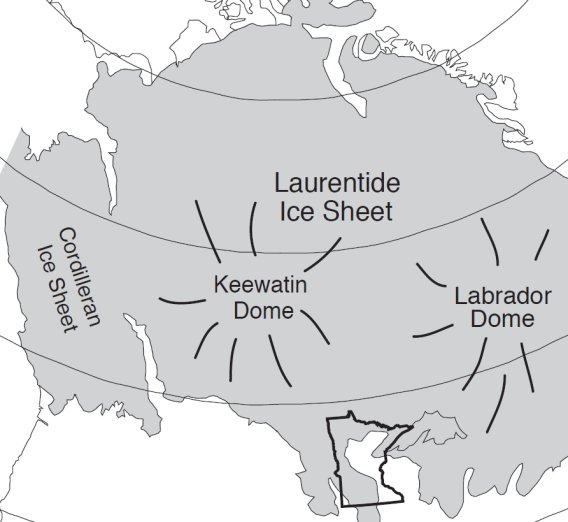
The Laurentide Ice Sheet (Fig. 1) covered much of northern North America throughout the Pleistocene Epoch. However, during interglacial periods, margins of the ice sheet likely retreated significantly.
Since Minnesota was at the edge of the ice sheet, it was not always completely covered with ice during glacial periods. Instead, Minnesota experienced numerous episodes of glaciation followed by ice-free periods.
Minnesota's Glacial History
Large, lobate "tongues" of ice covered Minnesota perhaps as early as 1.2 million years ago.
Evidence of the earliest ice advances, however, is buried under later deposits. Only in the southern corners of the state is any older till exposed, which may date back to 600,000 to 700,000 years ago (Fig. 1). The extreme southeastern corner of the state is called the "driftless area" (Fig. 1), where exposures of till are unknown or uncommon and it is believed that this region remained ice-free during most of the Ice Age.
Learn more about the "Driftless Area"
The bulk of glacial sediment in Minnesota is attributed to one time interval, the Wisconsinan Episode, which began about 75,000 years ago. During this time, the Laurentide Ice Sheet covered much of northern North America, with ice radiating outward from two high points, or domes, in the ice sheet. Changes in climate and precipitation caused these domes to shift periodically, changing the direction of ice flow. Thus, throughout the Ice Age, ice lobes advanced across the state several times from different directions (Fig. 1).
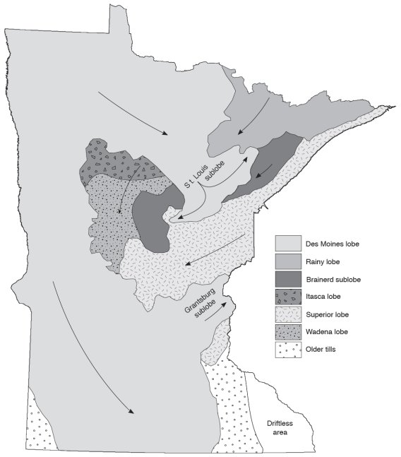
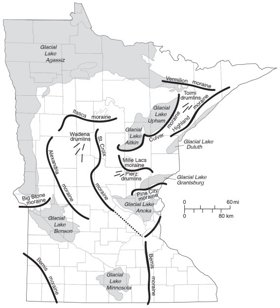
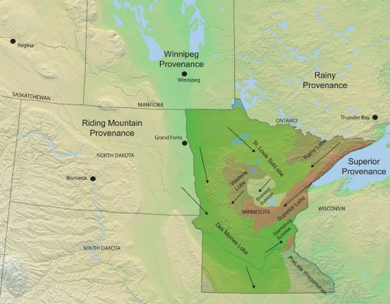
The Wadena ice lobe (Fig. 1) was active in the early to middle Wisconsinan glaciation. Deposits from this lobe are gray in color and contain limestone from the Winnipeg lowland in southern Manitoba. The Alexandria moraine and the Wadena drumlin field (Fig. 2) in west-central Minnesota are attributed to this ice lobe. The Rainy lobe (Fig. 1), which was active at about the same time (as well as several times subsequently), deposited a brown, sandy till that contains basalt, gabbro, and other rocks indicating a northeast source. A complex moraine system made up of the Itasca and St. Croix moraines (Fig. 2) marks the extent of the Rainy, Itasca, and Superior lobes together during the late Wisconsinan glaciation. In addition, two separate drumlin fields, the Toimi drumlins in northeast Minnesota and the Pierz drumlins (Fig. 2) south of the Mille Lacs moraine, record the combined movement of these ice lobes. Till from the Superior lobe is distinctly red in color and contains rocks derived from the Lake Superior basin, such as red sandstone and agates. The Mille Lacs and Highland moraines (Fig. 2) mark a later readvance of Superior-lobe ice into east-central Minnesota.
The most recent glacier to cross the state was the Des Moines lobe (Fig. 1). About 14,000 years ago, this ice extended through the Red River lowland in northwestern Minnesota south to Des Moines, Iowa. Two offshoots of the Des Moines lobe spilled over into other parts of the state: the St. Louis sublobe (Fig. 1) across northern Minnesota (marked by the Culver moraine [Fig. 2]) and the Grantsburg sublobe through east-central Minnesota (marked by the Pine City moraine). Des Moines-lobe till is gray to brown and is distinctive because it contains shale carried from North Dakota and Canada. The Bemis moraine (Fig. 2) marks the farthest extent of the Des Moines lobe and can be traced from northeastern South Dakota, through southern Minnesota and into Iowa (Figs. 1, 2). By 11,000 years ago, Minnesota was mostly ice-free; however, the Rainy lobe and the St. Louis sublobe were still present (though retreating) in the northern landscape and arrowhead region.
Throughout the Wisconsinan Episode, large lakes containing glacial meltwater formed along the margins of the ice lobes (Fig. 2). Glacial Lake Grantsburg was dammed north of the Twin Cities by the Grantsburg sublobe. Farther to the north, glacial Lakes Upham and Aitkin were formed in front of the St. Louis sublobe. Glacial Lake Duluth partly filled the Lake Superior basin in front of the Superior lobe. The largest lake, glacial Lake Agassiz, formed in the Red River lowland in northwestern Minnesota. At its maximum, glacial Lake Agassiz covered over 300,000 square kilometers across northern Minnesota, Manitoba, and Ontario. In other words, the surface area of glacial Lake Agassiz was greater than the surface area of all the Great Lakes combined! Water from glacial Lake Agassiz drained southward from this lake in glacial River Warren. This raging river created the large valley in which the Minnesota River now flows.
With each glaciation, the landscape was altered by the ice; in places the glaciers eroded the bedrock or previously deposited sediment, and in other places deposited enough sediment to form hills. As the ice retreated for the last time, the variable topography left behind resulted in numerous lows that then filled with water, becoming the lakes we know today. The glaciers are gone but the gently rolling hills, the deep river valleys, and even Minnesota's "10,000 lakes" are a testament to their passing.
Minnesota's Glacial "Footprints"
Deposits left by glaciers are the "footprints" that allow geologists to retrace the history of glacier movement.
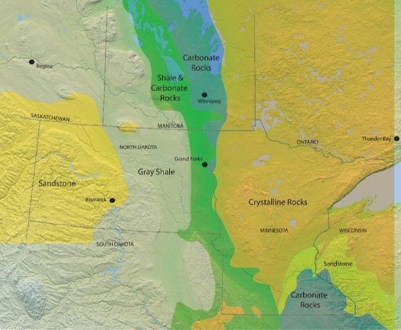
Till of a particular color and containing distinct rock types may indicate the direction from which the glacier advanced. In Minnesota, where the glacial history is complex, it is important to be able to determine where and when a glacier originated. One of the best ways to determine a glacial till deposit's place of origin (or its provenance) and to retrace the movement of a glacier, is by considering the geographic location and type of bedrock (or lithology) within the surrounding region (Fig. 1).
Doing so enables geologists to classify the various till deposits by provenance and, together with other geologic evidence, surmise the direction of ice-lobe movement across the landscape (Fig. 2). In Minnesota, four main till provenances are recognized. They are the Riding Mountain Provenance, Winnipeg Provenance, Rainy Provenance, and Superior Provenance (Fig. 2).
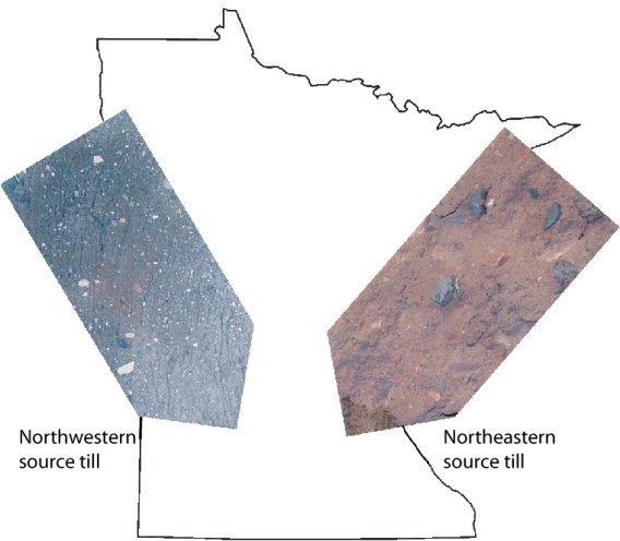
At the broadest level, the general source area of till in Minnesota can oftentimes be inferred by color alone (Fig. 3). Gray till, containing higher quantities of carbonate and shale bedrock, was most likely derived from a northwestern source area, while red till, containing higher quantities of crystalline bedrock, was most likely derived from a northeastern source area (Fig. 3).
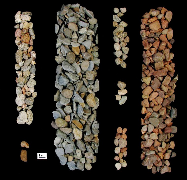
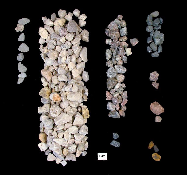
The Till Provenances: As Shown By Pebbles
Pictured below are end member pebble examples of the four till provenances of Minnesota based on the type of bedrock they contain and the quantity of each. Note the strong contrast in color between the northwestern-sourced pebbles and the northeastern-sourced pebbles.
Riding Mountain Provenance
NORTHWESTERN SOURCE AREA
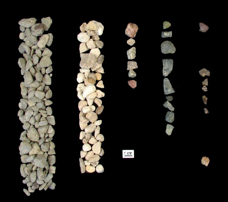
Winnipeg Provenance
NORTHERN SOURCE AREA
Rainy Provenance
NORTH-NORTHEASTERN SOURCE AREA
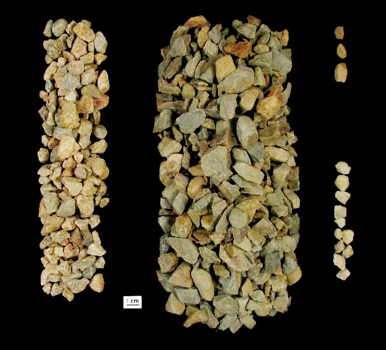
Superior Provenance
NORTHEASTERN SOURCE AREA