Precambrian Geology
Introduction
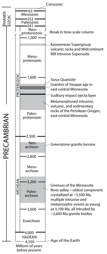
The great span of Precambrian time is divided into two major parts—the Archean Eon (4,550-2,500 million years ago [or Ma]) and the Proterozoic Eon (2,500-570 Ma). Each of these is divided still further (Fig. 1).
The ages of rocks are determined by measuring the tiny amounts of certain naturally occurring radioactive isotopes they contain.
Learn more about Geologic Time & Age Dating
Before isotopic dating methods were developed in the 1950s, the ages of rocks assigned to Precambrian time were not known. The igneous and metamorphic rocks beneath the younger sedimentary rocks were assigned arbitrarily to the Precambrian, without knowledge of the vast length of time they represented.
Today Minnesota geologists can split the Precambrian rocks into two, broad age categories: Archean and Proterozoic.
Paleoarchean to Neoarchean (2.6 to 3.5 billion years old)
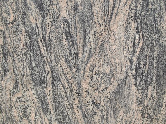
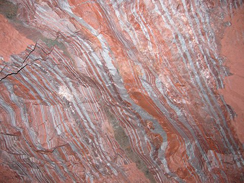
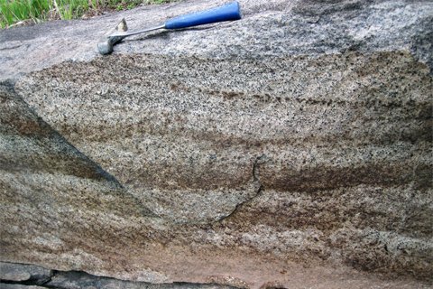
The oldest group of Archean rocks, which are Paleoarchean to Neoarchean in age (Fig. 1), is within the Minnesota River Valley subprovince. These rocks are exposed in the valley of the Minnesota River between New Ulm and Ortonville, and similar rocks underlie the southwestern quarter of the state beneath younger rocks and glacial sediment. Most of them are different kinds of gneiss (pronounced "nice"), a family of coarse-grained, streaky, or banded rocks (Fig. 2). These gneisses have undergone multiple events of igneous intrusion and were squeezed and deformed deep in the Earth's crust like taffy, producing the banded appearance we see today. The oldest components of the gneiss are between 3,500 and 3,100 Ma in age, but later, at around 2,600 Ma, after most deformation and metamorphism had ceased, the gneiss was intruded by several large bodies of granite, which have not been metamorphosed. These late granites can be seen near Fort Ridgely, south of Sacred Heart, and near Ortonville, among other places.
The gneissic rocks in this continental fragment that makes up the Minnesota River Valley subprovince are about 900 million years older than the Archean volcanic rocks of northern Minnesota.
Neoarchean (~2.7 billion years old)
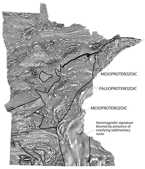
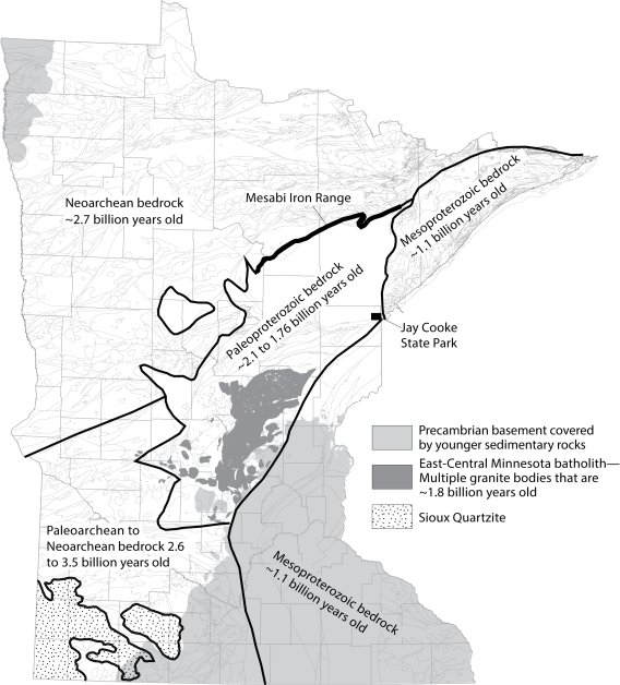
The younger Archean rocks (called Neoarchean) occur mainly in northern Minnesota, north of the Mesabi Iron Range, and may be seen in Voyageurs National Park, in the western part of the Boundary Waters Canoe Area Wilderness, and in scattered areas elsewhere between Lake of the Woods and Ely. This group includes the Wawa granite-greenstone subprovince, the Quetico subprovince (metamorphosed sedimentary rocks and gneiss derived from them), and the Wabigoon granite-greenstone terrane (Fig. 3).
The Wawa and Wabigoon subprovinces originally were parts of volcanic chains that were later deformed and intruded by granitic rocks; the Quetico subprovince was likely a large sedimentary basin on or between those volcanic arcs.
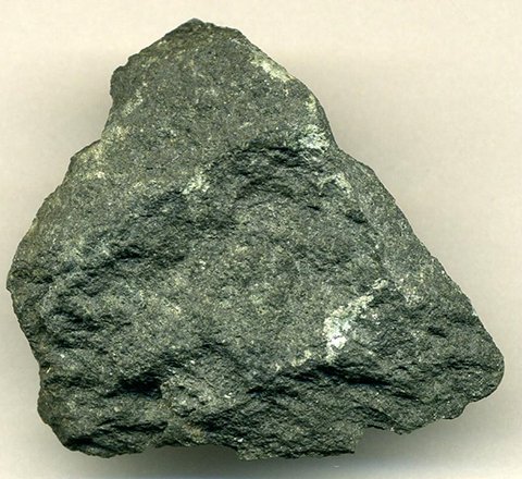
Greenstone (a dark greenish-gray, fine-grained, weakly metamorphosed basalt; Fig. 4), metadacite (a grayish-white, finegrained, metamorphosed volcanic rock), and graywacke (a layered gray rock made up of sand and mud eroded from volcanic sources) were the main materials in the upper parts of the Archean volcanic islands.
As these volcanic chains collided they were intruded by large amounts of granite and related coarse-grained rocks that crystallized at depth from the molten state, but are now revealed at the surface by deep erosion over time. The granites welded the greenstone belts together to form an Archean continent. The Neoarchean rocks, collectively, are called the greenstone-granite terrane. The Ely greenstone is a well-known example of Neoarchean rock.
Rocks of the gneiss terrane are quarried in the Minnesota River valley for use as building stone and are also crushed for road construction and railroad ballast, among other things. Rocks of the greenstone-granite terrane are also quarried for stone, and have been extensively explored for various metals including gold, copper, zinc, lead, and iron, but no deposits worth mining have been found, except for the now-closed iron mines near Ely and Soudan. The Soudan mine is open for public tours at Lake Vermilion-Soudan Underground Mine State Park.
Paleoproterozoic rocks
The southern part of the Paleoproterozoic terrane—approximately south of a line that runs west from Jay Cooke State Park—is a mixture of metamorphosed sedimentary and volcanic rocks. These were intruded later by several large granitic intrusions, emplaced between 1,800 and 1,760 Ma, which collectively form an amalgamation referred to as the East-Central Minnesota batholith.
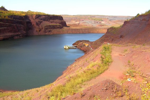
The northern part of this terrane is made up of slate and graywacke, iron formation (Fig. 1), and quartzite. The lowest part is quartzite—formerly sandstone—that was deposited on top of the older Archean bedrock. Above the quartzite is the Biwabik Iron Formation, long mined for its vast quantities of iron ore. Slate and graywacke overlies the iron formation and covers a vast area from the Mesabi Iron Range south to Jay Cooke State Park, where one can easily see that it has been folded and deformed.
The volcanic and sedimentary rocks (now metamorphosed) that make up the southern part of the Paleoproterozoic terrane are likely part of a former mountain belt—the Penokean orogen—that extended west from Lake Huron to South Dakota, and perhaps farther, about 2,000 to 1,800 Ma ago. The eroded remnants of this belt have geologic similarities to modern mountain belts along the west coast of North America, and geologists infer that mountains comparable to those in western California existed long ago in Minnesota. During this mountain-forming orogenic event, the crust was uplifted and a large basin formed to the north; sediment shed into this northern segment produced the thick sequence of slate and graywacke in the deeper parts, and along the North Shore, the Pokegama Quartzite and Biwabik Iron Formation were deposited. The East-Central Minnesota batholith was emplaced into the southern portion during this period of uplift and crustal collision.
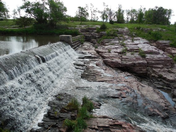
Slightly later in southwestern Minnesota, braided streams were flowing on an erosional surface developed on older Archean rocks within several fault-bounded basins, depositing sand layers. Later metamorphism has recrystallized the sandstone into the hard quartzite seen today in the bluffs at Blue Mounds State Park (Fig. 2). Thin beds of reddish-brown mudstone (catlinite) in the quartzite are still being quarried—and carved—at Pipestone National Monument.
The Mesabi Iron Range (Fig. 3) is one of the largest mining districts in the world, and in 2019 the mines in Minnesota and Michigan accounted for 98% of the usable iron-ore products in the United States. Several quarries developed in Paleoproterozoic granite operate throughout the state, providing building stone used not only in Minnesota but also around the world, as well as crushed rock and aggregate used for railroad and highway construction. The Sioux Quartzite also is quarried for aggregate.
Mesoproterozoic rocks
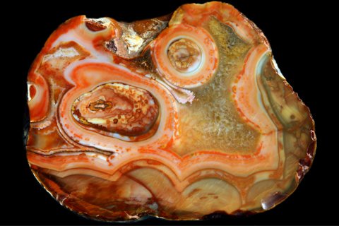
The Mesoproterozoic-age rocks are relatively unmetamorphosed compared to the other Precambrian rocks in the state. They consist mainly of gabbro (Fig. 4) and anorthosite, as well as volcanic rocks, such as basalt and rhyolite. These rocks formed around 1,100 Ma ago along the Midcontinent Rift system, a major feature that formed by the spreading apart of older continental crust. As the crust spread and thinned, fractures and faults formed; these provided pathways for molten magma from the mantle to work its way to the surface, where it erupted as volcanoes. The lava flows produced by these volcanoes are exposed along Lake Superior, and they have retained many well-preserved flow features, such as ropy tops of lava flows, which are the same as those in modern-day volcanic rocks in Hawaii. The popular Lake Superior agate, Minnesota's state gemstone, formed when vesicles (frozen gas bubbles) in these basalts were filled by thin bands of red and white quartz (Fig. 5). The base of the volcanic pile was intruded by magma that cooled more slowly below the surface, forming gabbro, anorthosite, and granite, some of which may have supplied magmas that were erupting as lava flows higher up in the sequence. When volcanism ceased, blankets of sand—now sandstone—were deposited in a basin on top of the volcanic rocks, for example the Hinckley Sandstone exposed in Banning State Park.