Mesozoic Geology
Rocks of Mesozoic age in Minnesota tell the story of two major marine trangressions (or sea level rises): one during the Jurassic Period (roughly 200 million years ago) and one during the Cretaceous Period (roughly 100 million years ago).
Jurassic rocks
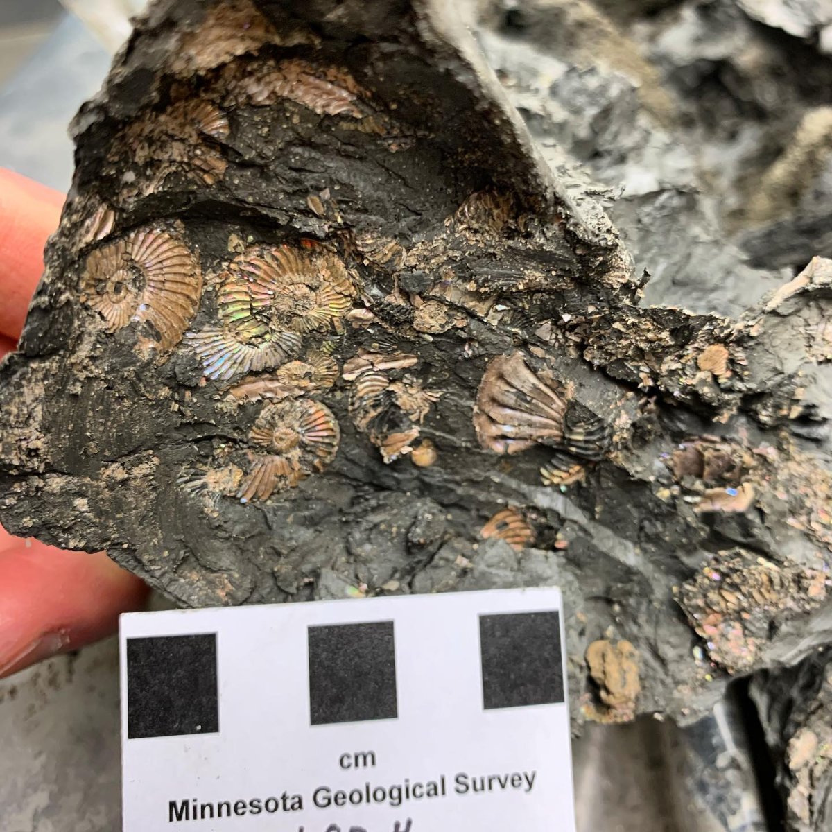
The poorly understood Jurassic rocks are known only from drill core samples in the far northwestern corner of the state (Fig. 1). These extremely heterolithic rocks were first recognized as a discrete unit by Allison (1932) and then informally named the Hallock red beds by Bayer (1959). As described by Jirsa and others (1994), the Hallock consists of:
- Green, gray, brown and red shale;
- Uniform to mottled white and tan micritic limestone and dolomite;
- Calcareous shale;
- Red, brown, and white fine- to coarse-grained sandstone and siltstone;
- Nodules of chert and possible gypsum.
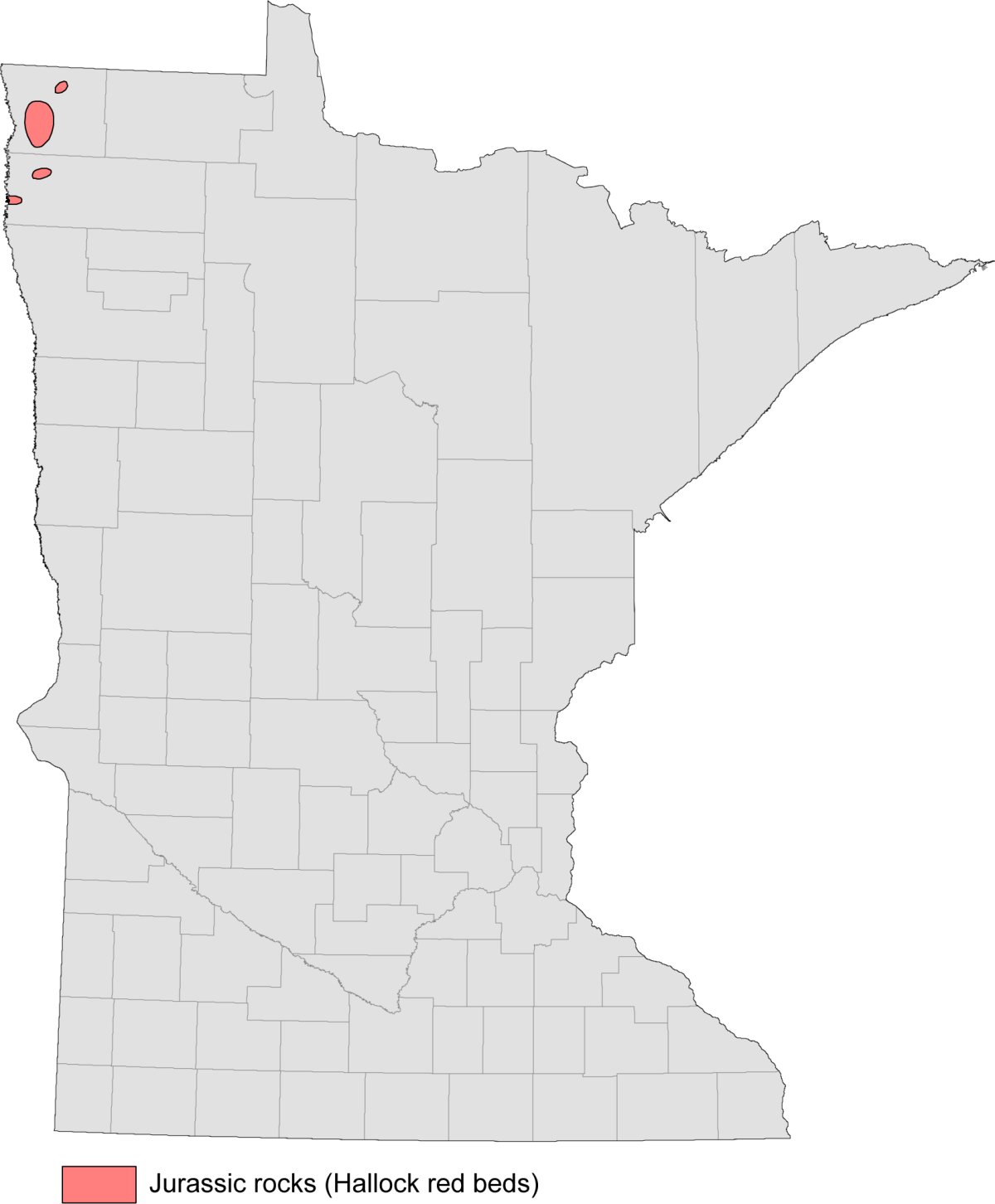
Mossler (1978) tentatively assigned a Jurassic age to the Hallock red beds due largely to their stratigraphic position (locally lying above the Ordovician Winnipeg Formation and below Cretaceous shale), general similarity to Jurassic strata in adjacent parts of Canada and North Dakota, and absence of kaolinitic clay in the shales (a clay mineral often characteristic of Cretaceous shales in Minnesota). The true origin and age of the Hallock red beds remain unknown. Jirsa and others (1994) suggested that the Hallock may be the fill of internally drained basins, a weathering residuum derived from the western-adjacent Red River Formation, or a combination of both.
Cretaceous rocks
The Cretaceous sedimentary rocks formed within a transitional marine and nonmarine environment along the eastern shoreline of a large inland sea, known as the Western Interior Seaway, that once split North America into two landmasses (Fig. 2).
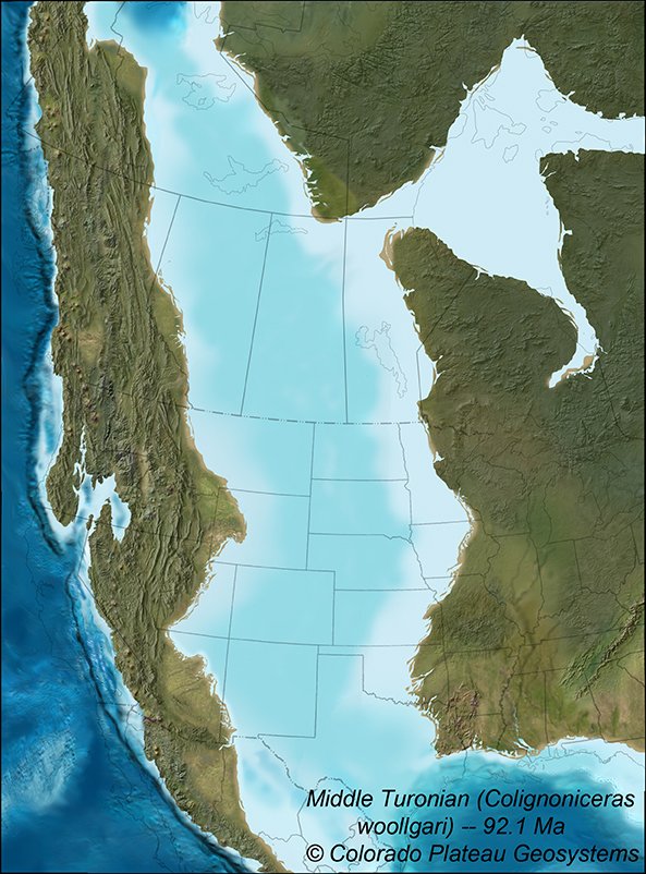
Photo courtesy of Colorado Plateau Geosystems
Prior to this, large areas of erosion or nondeposition existed throughout Minnesota. Early deposits largely consisted of river-deposited (fluvial) sand, kaolinitic clay and lignite (soft, low-grade coal), and were mostly confined to low areas on the Precambrian and Paleozoic bedrock surface.
As sea level within the Western Interior Seaway fluctuated over geologic time, so too did the location of its shoreline. Throughout the Late Cretaceous, the shoreline slowly advanced and retreated from west to east across Minnesota’s landscape. In turn, the boundary between the marine and nonmarine environments moved with the shoreline. Rocks deposited within the marine environment, such as mudstone, shale, marl, and minor limestone, are now largely confined to the western and northeastern portions of the state. Rocks deposited within the rivers and deltas of the nonmarine environment, such as conglomerate, sandstone, and mudstone, occur throughout Minnesota, but largely represent the numerous outliers in the southeastern portion of the state.
Western Minnesota
The Cretaceous rocks in southwestern Minnesota can be correlated with the better-known regional stratigraphy in South Dakota of the Dakota Formation, Graneros Shale, Greenhorn Limestone, Carlile Shale, Niobrara Formation and Pierre Shale (Fig. 3).
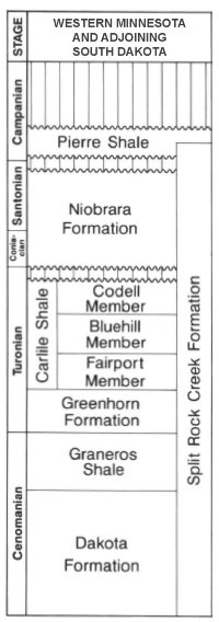
The Dakota Formation (Fig. 4) and Graneros Shale were deposited within mostly fluvial, deltaic and nearshore environments, as the waters of the Western Interior Seaway first began to rise and encroach eastward across Minnesota in the late Albian to Cenomanian. The Sioux Ridge, a series of topographic Sioux Quartzite bedrock highs in southwestern Minnesota, remained partly emergent as islands during this time. As sea level continued to rise into the early Turonian, carbonate deposition dominated the western half of southwestern Minnesota. This would become the marl and minor limestone deposits of the Greenhorn Limestone and portions of the lower Carlile Shale. Sea level began to fall in the later Turonian and thick marine shale of the Carlile Shale (Fig. 5) migrated seaward, covering the earlier carbonate-rich deposits. With the sea level falling and retreating further west, a period of nondeposition and possible erosion followed in Minnesota. Afterwards, another rise in sea level began during the late Turonian and Coniacian which led to the deposition of calcareous shale and siltstone of the Niobrara Formation. Following another period of nondeposition and possible erosion, shale and interbedded sandstone and siltstone of the Pierre Shale was deposited during the Santonian.
Photo courtesy of Julia R. Steenberg
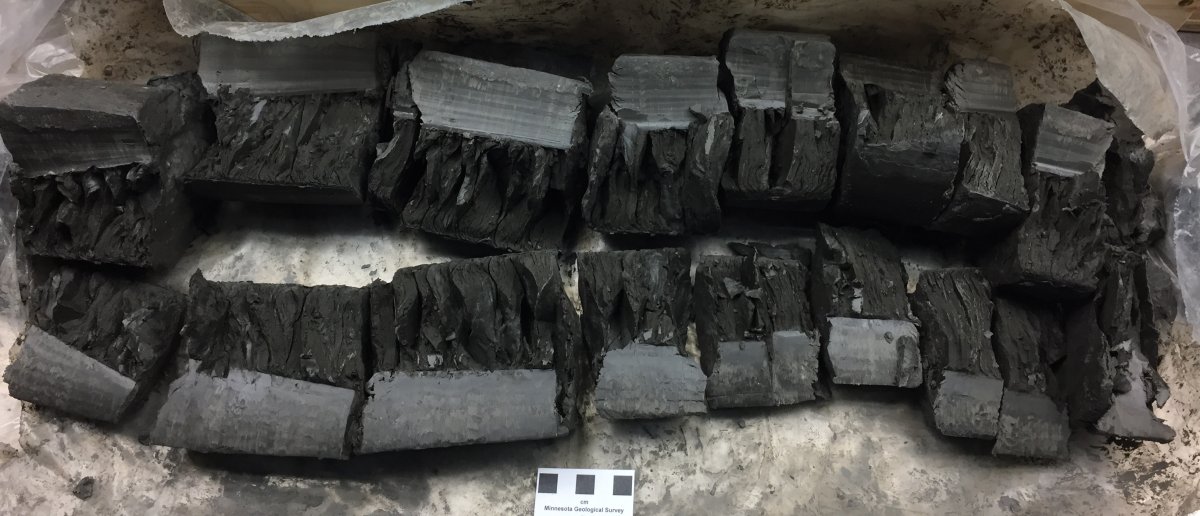
Photo courtesy of Andrew J. Retzler
Northeastern Minnesota
The Cretaceous rocks in northeastern Minnesota consist of conglomerate, sandstone, and shale assigned to the Coleraine Formation. The Coleraine Formation was deposited in a nearshore-marine and nonmarine environment, locally covering the irregular surface of the Precambrian bedrock in and around the Mesabi Range. These rocks are known to contain fossils of clams, snails, shark’s teeth (Fig. 6) and crocodile parts. Much of the formation has been excavated within the mines of the Mesabi Range, but the tailings piles still provide an excellent opportunity for future study and fossil discoveries. One of these mines, the Hill Annex Mine, was made into a state park in 1988. Visitors of the Hill Annex Mine State Park can get a closer look at the Coleraine Formation and even take part in fossil hunt tours.
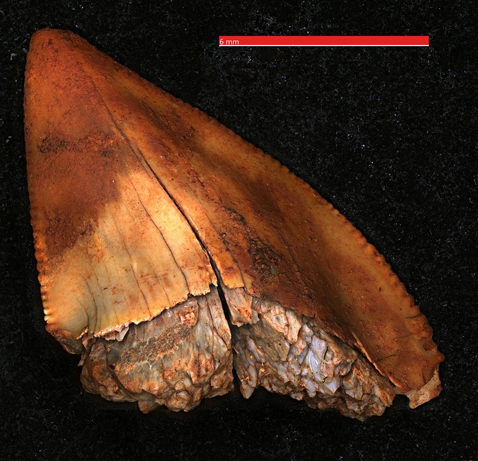
Photo courtesy of Rylan Bachman / CC BY (https://creativecommons.org/licenses/by/4.0)
Southeastern Minnesota
The Cretaceous rocks in southeastern Minnesota are assigned to the Windrow Formation (Fig. 7), comprised of a basal, iron-rich regolith (representing the Iron Hill Member) and overlying clay and poorly-cemented sandstone, pebbly sandstone, and conglomerate (representing the Ostrander Member). The Windrow Formation was deposited within a nonmarine setting in and along rivers and streams and as a terrestrial weathering by-product on top of the Paleozoic bedrock of southeastern Minnesota. These deposits can be patchy, variably thick and difficult to discern from overlying Quaternary glacial sediments without good quality samples to examine.
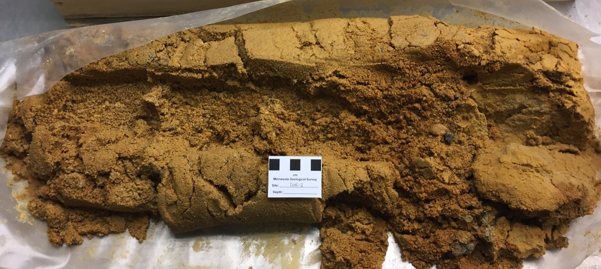
Photo courtesy of Andrew J. Retzler