News

Helicopter AEM Surveys Over Northeastern Minnesota
Posted
From now until the end of July, helicopter Airborne Electromagnetic (AEM) surveys will be conducted over northeastern Minnesota.

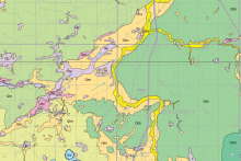
Geologic Atlas of Cook County Published
Posted
The Geologic Atlas of Cook County, Minnesota was recently published by the Minnesota Geological Survey.

Information Circular 48: Updated Nitrate Guidance for Minnesota
Posted
Newly published Information Circular 48 provides updated nitrate guidance for Minnesota based on a wealth of studies, investigations, reports, and Minnesota-specific water-quality data.

Geologic Atlas of Yellow Medicine County Published
Posted
The Geologic Atlas of Yellow Medicine County, Minnesota was recently published by the Minnesota Geological Survey, including map plates and GIS datasets.

MGS Guidance on the Coon Valley Member
Posted
New guidance available from the MGS on recognizing the Coon Valley Member and differentiating it from the Jordan Sandstone.

Print-On-Demand Atlases Now Available
Posted
The MGS has started a partnership with OceanGrafix to provide print-on-demand County Geologic Atlases. Only the latest CGA, C-59 Pipestone Atlas, is currently available.

Geologic Atlas of Pipestone County Published
Posted
The Geologic Atlas of Pipestone County, Minnesota was recently published by the Minnesota Geological Survey, including map plates, GIS datasets, and an online story map to provide web-based map data.

New Director and Minnesota State Geologist
Posted
We are delighted to announce the appointment of Dr. Robert (Bob) Tipping as our new MGS Director and State Geologist of Minnesota.
Steele County Atlas, Part A: Geology Published
Posted
The Steele County Atlas, Part A: Geology was recently published, with digital map plates and GIS datasets available online.
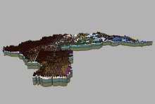
New 3D Geologic Models Published for GRAPS Pilot Project
Posted
Compilation geologic models for the Cannon, Missouri, and Redeye River Watersheds were recently completed as part of a two-year GRAPS Pilot Project in partnership with MDH.