Research: Earth's Water System

Earth's Water Cycle, Part 2: ...to Atmosphere to Space and Back
Two CEGE faculty, Xue Feng and Ardeshir Ebtehaj, explain their research on earth’s water system and the models that help them predict what might happen when water systems change.
ARDESHIR EBTEHAJ strives to advance a deeper and more predictive understanding of global changes in Earth’s water cycle.
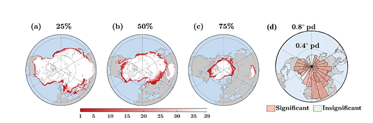
In a warming world, we see increases in the evaporation of surface water and in the capacity of the atmosphere to hold water. Over land, accelerated evaporation has increased the duration of droughts. Over oceans, rising sea surface temperature sends more water into the atmosphere, making severe storms stronger and more frequent. Other changes affect the frozen component of the earth system, the cryosphere, which has been shrinking at an unprecedented rate. Snowfall-dominated regimes are retreating poleward (Figure 1). The summertime meltwater of the glaciers and snowpack is declining in mountainous regions, threatening downstream socioeconomic development. The ice sheets and sea ice are melting, making coastal communities vulnerable to sea level rise.
Global changes in the water cycle— such as soil moisture, sea surface temperature, accumulation and melting of the cryosphere, and changes in snowfall—must be measured indirectly through remote sensing, using related data gathered via sensors on satellites. However, retrieval of water cycle variables through remote sensing often involves challenging inverse problems, by which scientists aim to infer water cycle variables from the indirect satellite observations.
Ebtehaj focuses on developing theoretical frameworks that link the mathematics of remote sensing retrieval problems to the laws of physics explaining transport of surface and atmospheric water. At the same time, he is devoted to developing data science techniques to efficiently incorporate high-dimensional information from satellite data to improve the forecasting skills of Earth system models.
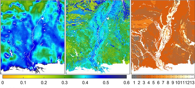
The fundamental question for Ebtehaj is this: how can the laws of water transport across the soil-vegetation- atmosphere continuum be incorporated into remote sensing retrieval problems? Answering this question requires development of theoretical frameworks that enable linking mathematics of remote sensing retrieval problems with the differential equations describing conservation of water mass and momentum. For example, we know from the laws of water flow in unsaturated porous media that the soil moisture dynamics are different in a cropland with predominantly silty soil from in a dense forest with organic soils. After looking at satellite data, initial results of his research show significant improvements in the ability of Ebtehaj’s model to estimate soil moisture from data gathered by satellite sensors when accounting for the soil water holding capacity and vegetation phenology (Figure 2). His hope is that following this line of research, a next generation of algorithms can lead to an improved and physically consistent approximation of climatic changes in the water cycle from satellite data.
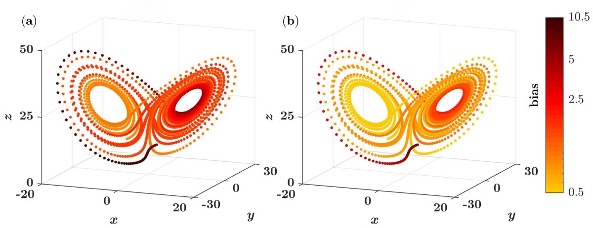
Ebtehaj’s research also seeks to reduce the uncertainty of weather and hydrologic forecasts by advancing the science of data assimilation through modern development in approximation theories. Ebtehaj’s team has recently developed new data assimilation techniques to account for systematic error in Earth systems models and improved predictions of extreme events—as shown for the Lorenz chaotic system of equations (Figure 3). The hope is that future expansions of these theoretical developments will result in a new paradigm that can significantly extend the lead time of hydrologic/weather forecasts.
Climatic changes in the Earth’s water cycle undermine global water and food security, threaten ecological diversity, hamper economic growth, and spark socioeconomic conflicts. Ebtehaj’s research will lead to improved understanding of climatic changes and will inform decision making to protect and conserve precious water resources. Moreover, his research contributes to efforts toward reducing uncertainties in prediction of extreme weather and hydrologic events, and will thus lead to more cost-effective management plans for natural disasters that can save lives and property.