What's Shaking at the Seismology Lab?
Written by Max Bezada
Seismic waves carry in them a wealth of information about the media through which they have passed. In the UMN seismology lab we’ve been busy trying to squeeze more of this information from the wiggles we record. Historically, one of the most useful observations gleaned from seismic data is the time it takes the wave to reach the sensor from the source. If you have enough sources and sensors, you can combine all this “travel time” information to figure out how fast the waves were traveling through different segments of their journey. In turn, this “propagation velocity” can be interpreted in terms of rock properties in the subsurface. In the Earth’s mantle, the propagation velocity is mostly determined by the temperature, but other factors such as the presence of melt, water content and the size of the mineral grains also have an impact.
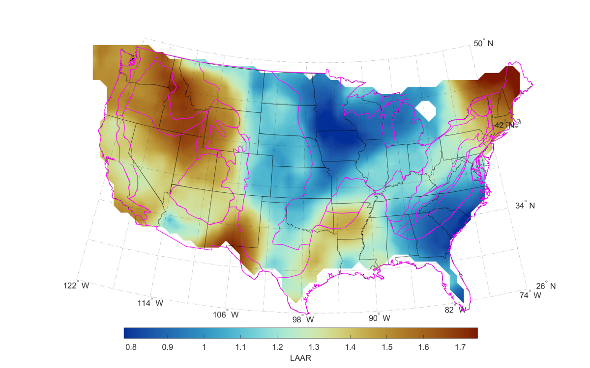
To try to disentangle the effects of different properties, we need more information than just the propagation velocity. One additional piece of information is what we call attenuation. As seismic waves travel through the subsurface, some of the energy they carry is used up moving individual grains past each other or even moving dislocations around the crystal lattices. It is a truly remarkable fact that seismic waves with km-scale wavelengths lose energy to processes occurring at the sub-mm scale, but such are the awe-inspiring physics of wave propagation. Because the effectiveness of these energy-stealing processes also depends on temperature, composition and grain size, combining constraints on wave propagation velocity and wave attenuation can help us better understand the state of the upper mantle. Unfortunately, attenuation is a notoriously difficult measurement to wrangle. Because of this, studies of seismic attenuation are far less numerous than their velocity counterparts. In the UMN seismology lab, we are striving to produce reliable measurements of seismic attenuation in the upper mantle.
Previous studies have focused on relatively small regions such as a section of the Appalachians, the Salton Trough in southern California or the central Rockies and the Black Hills. Most recently, we embarked on a quest to map seismic attenuation across the lower 48. Given the enormous size of the study area, this necessitated some innovations in the data processing workflow and entailed a lot of work from several members of our lab, but the project is now complete and close to being published in the Journal of Geophysical Research – Solid Earth. We found that across most of the conterminous U.S. attenuation behaves in the way we would expect, given what we know already from the state of the upper mantle. Surprisingly, however, we found significant changes in attenuation in the middle of the continent where one would have expected attenuation to be uniformly low. An integrated analysis with existing constraints on seismic velocity suggests that changes in attenuation across the older cratonic regions may be driven by lateral changes in grain size. This is a novel and intriguing hypothesis that will likely spur further investigation.
While the UMN seismology lab has primarily been focused on the study of upper mantle processes operating in the hundreds to thousands of km scales, over hundreds of thousands or millions of years, recently we have been expanding into the seismology of surface processes that occur at much smaller spatial and temporal scales. More specifically, we have been making an incursion into the rapidly evolving field of fluvial seismology. As the name suggests, this consists of trying to decipher information about processes occurring in rivers and streams from the information coded into the seismic waves they generate. We teamed up with colleagues at the Colorado School of Mines who had collected a unique seismic data set in Clear Spring, in Boulder. What makes this data set special is that it was collected with a relatively new sensing technology called Digital Acoustic Sensing. This tool allows us to record seismic data with a spatial density that is nearly impossible to achieve with conventional equipment. The data recorded was rich with different kinds of seismic arrivals and it was clear that there were changes in the characteristics of the seismic energy in different parts of the stream.
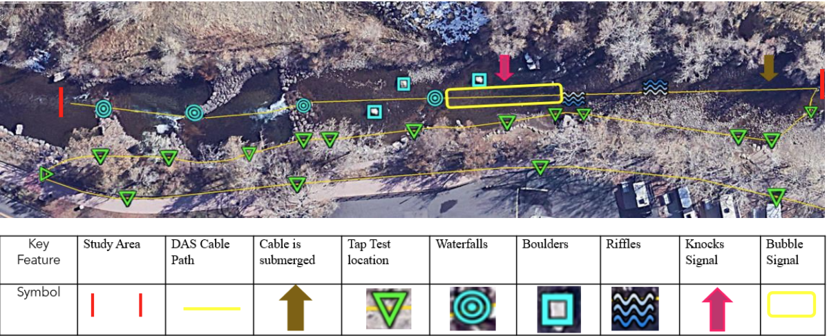
Our task at the seismology lab was to figure out what the likely sources of the seismic energy were, and what could be causing the changes in the frequency content of the signals along the study reach. We were able to locate and characterize different kinds of signals and associate them with stream morphology, the locations of waterfalls and even submerged boulders. We were also able to show that some of the signals were created not by the stream itself but by the interaction of the sensing equipment with the water and the stream bed. Although we made great strides in understanding this particular data set, we came away with many more questions than answers, and the goal of characterizing turbulence or sediment transport still lies beyond the horizon.
One of the challenges with fluvial seismology is that with natural rivers and streams it is not possible to control individual variables to isolate the effect of any one of them, as one would do in a laboratory experiment. In the near future, however, we intend to do just that by leveraging the resources at the Saint Anthony Falls Laboratory. In that remarkable facility, we would be able to systematically vary discharge, stream bottom roughness, and other factors and observe how each of those variables changes the nature of the seismic waves being produced. So far, we have collected preliminary data from floods run in the main channel. We expect these data will allow us to verify that the signal we’re interested in is observable above the seismic noise generated by all the other events going on in the building and we plan to use it to design an experimental campaign. Fluvial seismology is a young field and fertile ground for scientific advances, and we are confident that the unique resources at our disposal at SAFL will allow us to make important contributions.
In summary, whether deep beneath the surface or right under our feet, seismic waves encode information about our planet and our local environment. At the seismology lab we endeavor to develop and apply new ways to read this information and make the wiggles give up their secrets.